Friday, June 17, 2011

HIKING THE HIGH COUNTRY

We tried a second hike from Onion Valley only to be turned back due to deep snow after about 2.5 miles.  We ran into this guy on the way down.  Once agian there were Pacific Crest Trail hikes at the trail head looking for a ride to town.  This time just two of them, one from Maryland and the other from New Zealand.  People come from all over the world to hike the trail.  Here's a link to a site with information about the trail and other long distance trails in the United States

http://www.postholer.com/


ONE OF THE NATIVES

For the next hike, Cathie opted to take the day off, and I headed for Big Pine Creek.  With the trailhead at around 8500 feet it was well below the snow level.  I headed up the North Fork crossing the creek several times on bridges.  Most of the creeks are at their limits with the snow melt and creek crossings can be dangerous if not impossible.


At three miles, after a steady uphill climb a beautiful massive stone cabin comes into view.  Actor Lon Chaney built the 1200 square cabin in 1930 for $12,000.  The nearest road at the time ended 1.5 miles away and supplies and building materials were brought in by mule.  The cabin sits with the front porch facing the creek.  While I was there a fisherman pulled out two nice Rainbows, one over a pound.


After cooling down on the porch, I continued up the trail steadily climbing.  A couple of miles later I arrived at First Lake.  Yes, that's the lakes name.  There are 5 lakes along the trail so you can figure out their names.

FIRST LAKE


SECOND LAKE

A short distance up the trail is Second Lake.  It got really windy here, and cold.  I sat down out of the wind and ate my lunch while taking in the beautiful scenery.  At 5 miles from the trailhead and an elevation of 10,000 feet I figured there would be snow ahead so this is where I turned around.
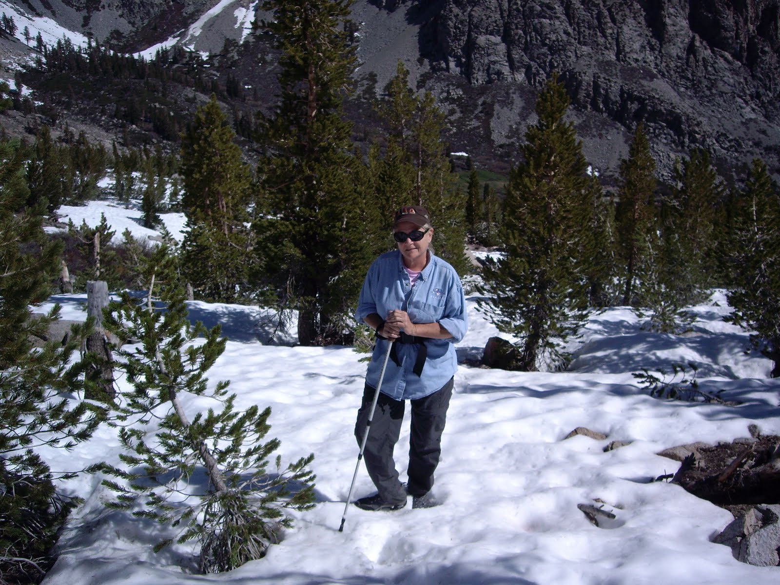

YOURS TRULY

The next day, Cathie having recovered with a day off, we headed up to Whitney Portal.  No we didn't climb Mt. Whitney.  Someday, perhaps, but at 22 miles round trip and the trial completely covered in snow after 2.5 miles, it was not in the cards. (I am not even ready to give it a try).  We did go ahead and hike up to Lone Pine Lake, the furthest you can go without a permit.  We saw lots of hikers who were intending on reaching the summit.  I wonder how many actually made it.  For us we were content to reach Lone Pine Lake, a sight to behold.


LONE PINE LAKE

On the way up the trail, we had to cross Lone Pine Creek.  I managed to cross on stones placed along the edge of the trail and only got one foot wet.  Cathie on the other hand has trouble doing anything that involves balance, so she took her boots off and waded across.  In the afternoon with the creek raising due to the snow melt, we both waded across.  The water was so cold it was actually painful.  Is that a look of pain on Cathie's face? Perhaps not. 


Well, we made it down safely and ended the hike with a great lunch at the Alabama Hills Cafe and Bakery in Lone Pine.  The lunch was so good that we're going there for breakfast in the morning before heading home.


Monday, June 13, 2011

THE EASTERN SIERRAS........AGAIN

The original plans was, Cathie was going to Oklahoma with her father to visit relatives and I was going to Big Pine to do some hiking.  Before I left and while Cathie was in Oklahoma, she called.  "Daaaannnna, will you please wait till I get home so I can go with you, pleeeeese".  Being the nice guy that I am, I agreed.  So here we are in an RV park just outside of Lone Pine doing day hikes in the high country.

With the massive snow fall this year, most hikes are limited to under 10,000ft, unless of course you want to hike in the snow.  Our first hike was to get acclimated to the elevation, so from Horseshoe Meadows at 10,000ft, we headed out on a pretty level trail.  Taking it easy we hiked about 6 miles entering the Golden Trout Wilderness.  Beautiful country with every stream at capacity.


HIGH COUNTRY MEADOW

CATHIE AND HER LOG BRIDGE

Cathie hates these things, like I hate hights.  This photo was taken on the way out after she crossed this one the second time and she's still dry.

For our second day we headed up to Onion Valley outside of Independence.  We attempted to reach Robinson Lake at 10,500 ft.  The trail, such as it was, was difficult to follow and according to the local ranger, no longer maintained.  After climbing up a steep slope, we hit snow around 9800 ft.  We hiked for a while in the snow, but decided we weren't properly prepared, so we headed back down.


When we reached the trail head, there was a group of backpackers who we learned were in the process of hiking the Pacific Crest Trail from the Mexican Border all the way to Canada.  They had come down to Onion Valley after 7 days on the trail from Kennedy Meadows, their last re-supply.  They had been hiking the PCT since April 18th and had hiked about 750 miles!  There was about 15 of them from different parts of the country and some from Denmark.  They didn't start out as a group, but met up on the trail and are pretty much hiking together.  They wanted to get to Independence for a re-supply and a little R&R for a couple of days and were looking for a ride.  Well, since we were heading that way, we told them to pile in.  Gunner, one of the hikers, and a badly infected toe, so we gave him a ride to the clinic in Lone Pine.  Asked why he was called Gunner, he told us it was because he was alway at the back of the group going slow.


So if you count them, thats 10.  The truck was packed, and after 7 days on the trail it got pretty ripe on the drive to town.  First stop, Subway for real food.  If you care to read about their hike, here's a link to one of their blogs.